FORT KNOX, Ky. – After a day of navigation practice, Cadets wake up to be tested on
their individual day land navigation skills. Equipped with only a compass, map, and
coordinates, Cadet’s venture alone through fields and woods to locate five points within four
hours.
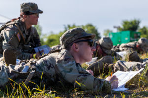
Cadets with 1st Regiment, Advanced Camp, plot coordinates on their map at the Land
Navigation Course on Fort Knox, KY., June 12, 2024. Before the Day Land Navigation
qualification, Cadets are equipped solely with a compass, map, and coordinates as they prepare
to locate five points within four hours.
| Photo Credit: Ayiana Andrella, Ohio University, CST Public Affairs Office
Sgt. 1st Class Charles Cassady, Georgia Tech, Cadre member at the Land Navigation
Course emphasizes that land navigation extends beyond simply navigating through the
woods. “It’s not just about using land navigation to know where they are and find a
point, but also about becoming proficient at planning and using a map, as well as
developing competence.” says Cassady. “Competence is important as it’s a leader
attribute that you understand navigation. Eventually, these Cadets will become
Lieutenant’s in the army, responsible for leading men and women as senior leaders.”
An hour into his day land navigation qualification, Cadet Stephen Wortendyke from
Lindenwood University, Nj., 1st Regiment, Advanced Camp, after locating one of his
points alongside the wooded area. His approach to this test involves “Recalling my
training, analyzing the situation,” says Wortendyke “and thoroughly reading my map.”
Leveraging the knowledge gained from his prior training, Wortendyke’s strategy plays
an important role in his navigation success.

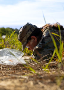
1st Regiment, Advanced Camp, Cadets Stephen Wortendyke from Lindenwood
University and Ramon Mora from Texas A&M University locate point 44 at the Land
Navigation Course on Fort Knox, KY., June 12, 2024. Wortendyke’s approach to the
Land Day Navigation test involves “Recalling my training, analyzing the situation,” says
Wortendyke “and thoroughly reading my map.” Point 44 is one of the many locations
Cadets must find in order to complete their land navigation qualification.
| Photo Credit: Ayiana Andrella, Ohio University, CST Public Affairs Office
Upon completing this qualification, Cadets emerge from the woods back to the start
point where they inquire about their results.
Cadet Jenna Stickley from Cornell University, Nj, with 1st Regiment, Advanced Camp,
plots her coordinates at the Land Navigation Course on Fort Knox, KY., June 12, 2024.
Before the venture into the woods for the Day Land Navigation Test, Cadets are
assigned 5 points and provided with corresponding coordinates to locate.
| Photo Credit: Ayiana Andrella, Ohio University, CST Public Affairs Office
Undeterred by the Cadets being left to their own devices, 1 st Regiment, Advanced
Camp, Cadet Connor Bluestein from Virginia Tech manages to locate all five points
within two hours. Bluestein perceives that the Day Land Navigation test is intended to
instill self-confidence. “You have to trust your skills; you’re not asking for assistance or
resorting to your phone for a GPS. says Bluestein. “It’s about relying on your self-
complete confidence that you know where the point is.”
Despite their physical and mental exhaustion, this qualification can enhance Cadets
confidence and prepares them thoroughly for the upcoming night land navigation
qualification. Once completing the day land navigation qualification, Cadets can feel
slight relief, acknowledging that they are one step closer to finishing their summer
training.

